GPS
The GPS-chip installed in the iPhone® allows Eco:Map to determine your location. Its speed and accuracy are highly dependent on the local conditions. The following principle applies: the higher the level of precision required the longer it will take and therefore the more of your battery life will be used. As a compromise between the two parameters, speed and accuracy, an accuracy of 100 metres and a maximum search time of 30 seconds is preset by Eco:Map. Eco:Map tries to automatically locate you within 30 seconds, accurate to at least 100 metres, as soon as you arrive at the Individual find dialogue (see picture at the bottom left). You can find out here how to change the presets.
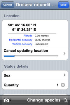
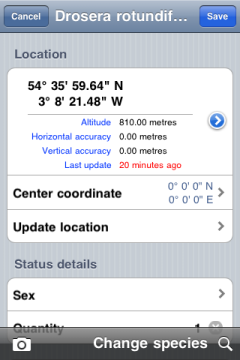
On the left you can see how Eco:Map locates your position shortly after selecting the Individual find dialogue. During the search the ongoing measurement readings can be seen. The altitude, horizontal and vertical accuracy are also displayed. You can stop the operation at any time by tapping on Cancel updating location.
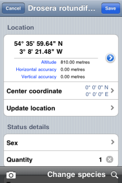
On the right you see the same dialogue after the search has ended. By selecting Update location you can start the positioning process anew and possibly improve the accuracy. This can be useful if, for example, you use Eco:Map immediately after rebooting your iPhone®.
Presets
In this dialogue you see Eco:Map's available presets. You get there by choosing Main menu > Settings > GPS.
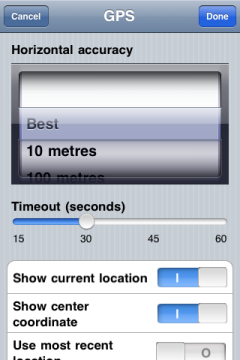
In the picker view Horizontal accuracy you can set the accuracy with which your location is determined. You can choose between four different levels: Best, 10 Metres, 100 Metres und 1 Kilometre. The level Best prompts Eco:Map to search until a horizontal accuracy of 0 metres is reached. However, in practice this is not likely to happen. Trials in the author's home town showed a maximum accuracy of 17 metres. The position transmitted by the iPhone® was the centre of a circle with a radius of 17 metres, inside which the actual location of the author could be determined.
With the slider Timeout (seconds) you can determine the maximum search time. After the expiration of this time span updating location is cancelled by Eco:Map. The most precise value determined until then is suggested to be saved in the database.
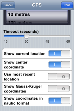
Activating Show current location means that your current location is displayed on maps.
Use Show center coordinate to display the center coordinate of a field trip (red pin).
When you get into the Individual find dialogue, Eco:Map automatically activates the positioning system but if you select Use most recent location instead, you have to activate the positioning system yourself by tapping on Update location. With this setting the last saved location is suggested to you with every new find. Thereby you can map without extra energy consumption when finding several species in one location. This last position is available to you even after a restart of Eco:Map. If the last positioning dates back more than 10 minutes you will see, in red, advice in the line Update location with the date and the last location.
Tap Show Gauss-Krüger coordinates if you want to see your finds' positions in Gauss-Krüeger coordinates.
Show coordinates in nautic format switches between nautic and decimal representation of coordinates.
Location Services
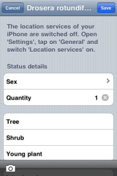
In order to determine your location more rapidly the iPhone® uses mobile communications networks. Every user of an application processing GPS data therefore has to activate in his iPhone®-Settings under General the Location Services. If you had chosen to switch off your location services you'll be asked to do so.